The Boyne Valley’s Historical Landmarks
While you are on a gastronomic adventure in the Boyne Valley it would be impossible not to discover and take in some of the amazing landmarks and legends that are woven into the fabric of these ancient lands.
The Boyne Valley is Ireland’s ancient capital, its most sacred and mythical landscape and the birthplace of Ireland’s Ancient East. There is 5,000 years of history at Boyne Valley, with the Brú na Bóinne monuments dating back further than Egypt’s Pyramids of Giza!
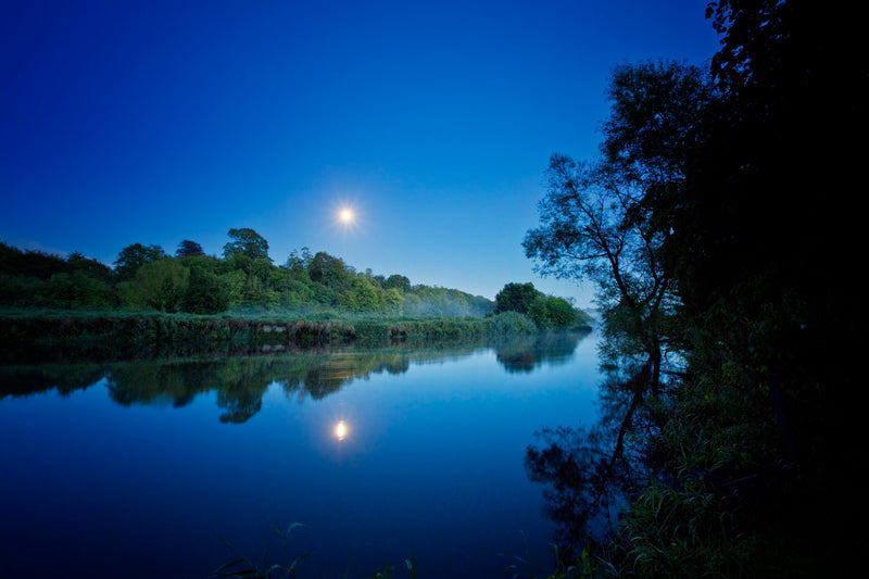
The River Boyne is a river in Leinster, Ireland, the course of which is about 112 kilometres long. It rises at Trinity Well in County Kildare, and flows towards the Northeast through County Meath to reach the Irish Sea between Mornington, County Meath, and Baltray, County Louth.
Despite its short course, the Boyne has historical, archaeological and mythical connotations. The Battle of the Boyne, a major battle in Irish history, took place along the Boyne near Drogheda in 1690 during the Williamite war in Ireland. It passes through the ancient town of Trim, Trim Castle, the Hill of Tara (the ancient capital of the High King of Ireland), Navan, the Hill of Slane, Brú na Bóinne (a complex of megalithic monuments), Mellifont Abbey, and the medieval town of Drogheda. In the Boyne Valley can also be found other historical and archaeological monuments, including Loughcrew, Kells, Celtic crosses, and castles.
This river has been known since ancient times. The Greek geographer Ptolemy drew a map of Ireland in the 2nd century which included the Boyne, which he called Βουουινδα (Bouwinda) or Βουβινδα (Boubinda). During the High Middle Ages, Giraldus Cambrensis called it the Boandus. In Irish mythology it is said that the river was created by the goddess Boann and Boyne is an anglicised form of the name. In other legends, it was in this river where Fionn mac Cumhail captured Fiontán, the Salmon of Knowledge.
Our Boyne Valley Map features some of the more recognized landmarks across the Boyne Valley and here we have some further information on them and you can find more on the history of the Boyne Valley and other important historical locations on the Discover Boyne Valley site HERE
Trim Castle
Trim Castle is the largest, best-preserved & most impressive Anglo-Norman castle in Ireland. Trim gets its name from the Irish Baile Átha Troim, meaning ‘Town of the Ford of the Elder Trees', indicating that this was an important fording point on the River Boyne. Such was the significance of this crossing point that by the fifth century a chieftain's dún (fort) and an early monastery were sited here. Trim Castle was built In 1172, shortly after the arrival of the Anglo-Normans in Ireland. King Henry II granted his baron Hugh de Lacy the Kingdom of Meath, along with custody of Dublin. The King feared that another of his barons Richard de Clare (also known as Strongbow) might set up a rival Anglo-Norman kingdom in Ireland, and gave de Lacy Meath as a counterbalance to Strongbow's powerbase in the south of Leinster.

For strategic reasons, de Lacy decided to make Trim, rather than Drogheda, the centre of his newly acquired lordship. De Lacy converted a ringfort into a wooden castle with a spiked stockade. This structure was seen as a threat by the Gaelic Irish and in 1174 Rory O'Connor, King of Connacht (and last High King of Ireland), attacked and it was destroyed. The following year work began on a more permanent stone replacement and over the following decades Hugh de Lacy (d. 1186) and his son Walter constructed the largest Anglo-Norman castle in Ireland. Initially a stone keep, or tower, replaced the wooden fortification. The keep was remodeled and then surrounded by curtain walls and a moat. The wall, punctuated by several towers and a gatehouse, fortified an area of about 3 acres. Most of the castle visible today was completed by 1220.
Trim Castle passed from the de Lacy family to Geoffrey de Geneville, an important French knight and crusader who had become a loyal supporter of Henry III of England and his son Edward I. Geoffrey built the great hall beside the keep and founded the Dominican Blackfriary in the north of the tow. From the de Geneville family it passed to the Mortimers (including the imfamous Roger Mortimer who helped his lover Queen Isabella depose her husband Edward II). From the Mortimers it then passed to being a possession of the Duke of York until the War of the Roses, when it was finally seized as a royal property.

The unique twenty-sided cruciform design of the keep (with walls 3m thick) is an example of the experimental military architecture of the period. It served as both the domestic and administrative centre of the castle. By 1500 much of Ireland was back in the hands of Gaelic Chieftains and the territory under English control had been reduced to an area around Dublin, known as ‘The Pale'. By this time Trim Castle was in decline; however, it remained an important outpost protecting the north- western frontier of The Pale.
Over the centuries Trim Castle was adapted to suit the domestic needs of its owners and the changing political climate. However, much of its fabric has remained unchanged since the height of Anglo-Norman power in Ireland. Even today when standing within the walls of the castle visitors can get the sense of security that would have been felt by the de Lacy family in a hostile landscape. Although, standing outside the walls you can sense the intimidation that must surely have been felt by the native population.
Slane Castle
Slane Castle, County Meath has over 300 years of history, from the castle's first major reconstruction under the direction of William Burton Conyngham in 1785, to the famed concert that revolutionized the Irish music scene in the 1980s, to the delicious Irish whiskey distilled there today.
The Hill of Slane, which overlooks the Castle, is where St. Patrick lit his paschal fire, following which he was summoned by the High King to Tara, and Ireland was subsequently converted to Christianity. Nearby is Newgrange, one of the earliest and most significant and dramatic structures in Western Europe. The historic Battle of the Boyne was fought just downriver.
The Conynghams are originally a noble Scottish family, and settled in Ireland in 1611 in Co. Donegal. There has been an active association between the Conynghams and the Slane Estate dating back over 300 years, ever since the property was purchased by the family following the Williamite Confiscations in 1703.
Albert Conyngham and his son Major General Henry Conyngham fought in the Battle of the Boyne in 1690, and the Major then went on to purchase the land that Slane Castle — and Slane Distillery — now rest on. His relatives and descendants were committed to the area, with William Burton Conyngham planning out and improving the Village of Slane in 1781.
The Castle itself is one of the most exciting historic buildings on the island and displays the collective talents of some of Ireland and England’s most distinguished architects. The parklands were laid out by the distinguished landscape architect, Capability Brown.
Slane’s name is familiar to rock ‘n roll fans the world over. Since launching in 1981 by Henry Conyngham, the Slane Castle Concert series has attracted more than 1 million rock ‘n roll fans who flock annually to the estate’s idyllic grounds. Headliners have included David Bowie, Bob Dylan, Queen, The Rolling Stones, Bruce Springsteen, Bon Jovi, U2, Madonna, the Red Hot Chilli Peppers, and Oasis.
Thin Lizzy headlined Slane with their charismatic singer Phil Lynott at the first show in 1981. In 1984 the band lived in the Castle while they were recording The Unforgettable Fire. The Drawing Room was converted into a recording studio and one of the videos for Pride was filmed in the unique Gothic Revival Ballroom which was created for George IV’s State Visit in 1821.
Slane Irish Whiskey is a bold, new take on Ireland’s legendary spirit. Created by Brown-Forman, a leader in whiskey since 1870, and the Conyngham family , it unites craftsmanship and innovation. These two historic families rooted in shared values have joined together to introduce this unique Irish whiskey.

Hill of Tara
The Hill of Tara is a low-lying ridge located between Navan and Dunshaughlin in Co. Meath. It is said that a quarter of the landscape of Ireland can be seen from the hill. Tara gets its name from Teamhair na Rí meaning ‘sanctuary of the Kings.' It is important as the traditional inauguration site of the ancient High Kings of Ireland. Although few of its monuments survived the test of time, it is an evocative place, much celebrated in Irish myth and legend.

The mythology of Tara
Tara is most synonymous in myth as the residence of the High King of Ireland (although the archaeology suggests there were no permanent residences on the hill). The legend of Conn of the Hundred Battles illustrates the importance of Tara and tells us how the Kingship of Ireland was granted by the otherworld.
Conn, his druids and his fili (poet seers), in their efforts to protect Ireland from the people of the otherworld mounted the ramparts at Tara. He stepped on a stone that let out several loud cries. Each cry represented a descendant of Conn's that would be High King. He had stood on the Lia Fáil, the Stone of Destiny, said to cry out when a true King entered Tara. Conn was granted Tara by Lug, the good god. Lug instructed the beautiful goddess Medhbh, whom he proclaimed was “the Sovereignty of Ireland,” to serve Conn a drink of ale from her vat. Lug then instructed her to offer each of Conn's successors a drink from her vat until the Day of Judgement.
The archaeology of Tara
Tara was an important site long before the High Kings. A passage tomb known as Dumha na nGiall (meaning ‘the mound of the hostages') is the oldest visible monument and dates from around 3,000 BC. However, Tara became truly significant in the Iron Age (600 BC to 400 AD) and into the Early Christian Period. In 433 St. Patrick, on the nearby Hill of Slane, lit the Paschal fire in defiance of the Pagan King of Tara. Tara was the royal centre of Mide (meaning ‘the middle kingdom'), the fifth province of ancient Ireland. It incorporated the present Co. Meath and what is now Westmeath and large parts of Cavan and Longford. One of the most interesting monuments at Tara is the Lia Fáil (Stone of Destiny), which is a standing stone located within an area known as the Forrad (The Royal Seat). This was the inauguration stone of the Kings of Tara. According to tradition, when a true Irish or Scottish King placed a foot on Lia Fáil it cried out to announce his rightful reign.
Tara was finally abandoned, in 1022, by the then High King of Ireland Mael Shechlainn. However the hill has always retained its importance to the Irish identity.
The Battle of Tara, 1798
On 26 May 1798, at the beginning of the United Irishmen's Rebellion, an army of Meath's United Irishmen & Defenders were heavily defeated by government forces at the Hill of Tara. Around 4000 rebels had camped here, because of its symbolism of ancient Gaelic sovereignty and also due to its strategic position overlooking the Dublin-Ulster road. The counterattack began in the evening, government forces assembling on the southern slopes of the hill. Three companies of Scottish fencibles & one 6lb cannon were joined by six local yeomanry cavalry corps & two infantry corps. Captain Blanche of the Reay Fencibles commanded the c.300 men. The government forces advanced up the hill from the south and the enthusiastic (but untrained) rebels charged down, abandoning their superior position. Trained musketry inflicted heavy casualties as did point blank cannon fire. The rebels retreated to the ruined church (later rebuilt in 1822) but the Reay grenadiers drove them out. Blanche suffered only 41 casualties & 9 fatalities. It is said that c.400 dead rebels were buried in a mass grave in the Forradh monument & the Lia Fáil was moved there (from its original location near the Mound of the Hostages) to mark the spot. The two gravestones on the Hill commemorate the battle.
Modern Tara
In 1843 an estimated one million people gathered there to hear Daniel ‘The Liberator' O'Connell speak against the Union of Great Britain and Ireland. Like the rebels in 1798, O'Connell chose Tara as a location due to its strong symbolism to the Irish people. A group calling themselves the British Israelites conducted a series of amateur excavations at Rath na Seanadh (The Rath of Synods) between 1899 and 1902. They believed the Ark of the Covenant was buried there, based on myths connecting the Bible, Egypt and Ireland. In 1902, in a letter to the Editor of The Times, Tara was described by Douglas Hyde, George Moore and William Butler Yeats, key figures in the Gaelic Revival, as ‘the most consecrated spot in Ireland. Eventually the digs were stopped, but not before significant damage was done. These myths were probably designed by the early Irish monks to draw connections between the Bible and the prehistory of Ireland.
Loughcrew Cairns
The Loughcrew Cairns are one of Ireland’s archaeological treasures and can be found just 3km east of Oldcastle, County Meath. The site comprises a group of 5,000-year-old Neolithic passage tombs.
The Loughcrew Cairns site is one of the four main passage tomb sites in Ireland, thought to date from about 3300 BC. The sites consist of cruciform chambers covered in most instances by a mound. A unique style of megalithic petroglyphs are seen there, including lozenge shapes, leaf shapes, as well as circles, some surrounded by radiating lines.

The site is spread across three hilltops, Carnbane East, Carnbane West, and Patrickstown. The Irish name for the site is Sliabh na Caillí, which means "mountain of the witch". Legend has it that the monuments were created when a giant witch, striding across the land, dropped her cargo of large stones from her apron. The orthostats and structural stones of the monuments tend to be made of local green gritstone, which was soft enough to carve, but also vulnerable to vandalism.
Situated just 3km east of Oldcastle in County Meath, the tombs are spread out over three different hills. Cairn T is one of the best preserved and most accessible tombs at Loughcrew and appears to be the central tomb of the whole complex. It faces the rising sun at the vernal (March) and autumnal (September) equinoxes which shines through the passage to illuminate symbols carved into the back wall of the chamber, corbelled roof and stunning examples of Neolithic art.
This tomb is reputed to be the resting place of Ollamh Fodhla a legendary King of Ireland. During the vernal and autumnal equinoxes, people traditionally gather at dawn to watch sunlight enter the Cairn T chamber and illuminate the interior of the tomb. A site of considerable historical importance in Ireland, Loughcrew Cairns is one of the jewels in the crown of the Boyne Valley.
Kells High Crosses
Kells derives from the Irish Ceanannas Mór, meaning ‘great residence`. Long before the coming of Christianity, Kells was a royal residence associated with the legendary Conn Céadchatach (Conn of the Hundred Battles) and Cormac mac Airt. In 550 St. Columba, also known as St. Colmcille, established a religious settlement at Kells. In 563 he went into self imposed exile of the Isle of Iona, off the west coast of Scotland and founded another settlement. The island was raided by Viking fleets in 795, 802 and again in 804 when sixty-eight people were killed. Shortly after, the community of St. Columba's monastery on Iona were granted lands at Kells as a safe haven from invaders.

Generally, monastic settlements were surrounded by a circular boundary wall called a vallum, which acted as a frontier between the holy world within and the secular world outside. They often contained a church, graveyard, high crosses, monk cells and from the late 10th century round towers also became a feature.
The first church at Kells was completed by 814 and in 878 the relics of St. Columba were relocated from Iona, which was now prospering. However, Kells itself was raided by the Vikings in 919, 950 and 969, and many times throughout the 11th century, this time by the Irish. The most famous treasure created by the community of St. Columba is the Book of Kells, a highly ornate version of the four gospels in Latin. It was written around the year 800, though it remains unclear whether it was written in hole or part at Kells.
Although Kells became an important Anglo-Norman walled settlement, it is its monastic heritage that best survives. ‘Kells` round tower, though roofless, stands at height of 25m. In 1076 Murchadh Mac Flainn, who was fighting for the High Kingship of Ireland, was murdered in the tower. The tower is surrounded by several finely carved high crosses, in various states of preservation. A stone church known as St. Columba`s House, dating from the 9th century is possibly the oldest surviving structure in the town. It is a classic example of an early Irish church with a steeply pointed stone roof. The Kells Courthouse was originally designed in 1801 by Francis Johnson, who also designed the GPO on O`Connell St. Dublin. The Market Cross of Kells, which dates from the 9th century and depicts scenes from the Old and New Testaments, can be seen at the junction of the Navan / Dublin (N3) road and the Slane road in front of the Kells Heritage Centre. Commence the Kells Historic Trail at Kells Couthouse where a map can be obtained.
Mellifont Abbey
The first Cistercian monastery in Ireland founded in 1142 by St Malachy of Armagh, its most unusual feature is the octagonal Lavabo c. 1200. The Visitor Centre houses an interesting exhibition on the work of masons in the Middle Ages with fine examples of their craft on display. Access to site by stone stairway. The site is now fully accessible.

The abbey imported it's formal style of architecture from the abbeys of the same order in Europe.The abbey was consecrated in 1157 and from this humble beginnings the Cistercian community spread out throughout Ireland founding other abbeys throughout the country with Mellifont being the model on which these abbeys were based. The most significant remains of Mellifont Abbey is the chapter house, the Lavabo where the monks would have washed their hands before meals and the impressive Gateway. The other parts of the Abbey are gone but small walls remain making it possible to make out how the Abbey would have looked.
A visitors centre was recently opened at the Abbey in the building used for Ireland`s first Youth Hostel. The centre contains some of the carvings found during excavations of the site. Guided tours are also available from 30th May to 28th August.
By 1170, Mellifont had one hundred monks and three hundred lay brothers. The Abbey became the model for other Cistercian abbeys. It was the main abbey in Ireland until it was closed in 1539, when it became a fortified house.
Monasterboice
The historic ruins of Monasterboice (Irish: Mainistir Bhuithe) are of an early Christian settlement in County Louth in Ireland, north of Drogheda. It was founded in the late 5th century by Saint Buithe who died around 521, and was an important centre of religion and learning until the founding of nearby Mellifont Abbey in 1142.
The site houses two churches built in the 14th century or later and an earlier round tower, but it is most famous for its 10th century high crosses.
In the 5th century, St Buite founded a monastic community near Drogheda in County Louth and today, it is home to an impressive collection of ruins.

On the site, visitors can discover an old graveyard, two churches and a sundial. Another highlight is undoubtedly the well-preserved round tower, which stands at 28m high. There are also two spectacular high crosses: Muirdeach's Cross and the West Cross, noted as being the tallest in Ireland. The 5.5-metre Muiredach's High Cross is regarded as the finest high cross in the whole of Ireland. It is named after an abbot, Muiredach mac Domhnaill, who died in 923 and features biblical carvings of both the Old and New Testaments of the Bible. The North and West crosses are also fine examples of this kind of structure, but these have suffered much more from the effects of the weather.
Monasterboice was a thriving centre of religion and learning until 1142, when the Cistercians arrived at the nearby Mellifont Abbey The round tower is about 35-metres tall, and is in very good condition, although it is not possible to go inside. The passage of time has laid down layers of earth so now the doorway is almost at ground level. The monastery was burned in 1097.
Brú na Boinne- Newgrange, Knowth and Dowth
Newgrange
Newgrange (c 3,200 B.C.) is the best-known monument of the World Heritage Site of Brú na Bóinne, predating the ancient pyramids by 400 years and Stonehenge by 1000. The passage tomb is surrounded by 97 kerb stones, the most impressive is the large entrance stone which is covered in swirls and designs. Inside the large mound there is a long passage leading into a chamber which branches off three ways. The corbelled roof inside the burial chamber it still watertight and supports an estimated 200,000 tonnes of cairn. The cremated remains of the dead were laid on large stone basins inside the chamber which usually were accompanied by grave goods.

At dawn on the winter solstice, the shortest day of the year (December 21st), a shaft of sunlight enters the chamber of Newgrange through a specially designed opening over the doorway which illuminates the Chamber. On December 21st 1967, Professor MJ O'Kelly was the first person in modern times to see this now world famous event.
Knowth
The passage tomb complex lies to the west of Newgrange. The large mound covers two passage tombs placed back to back which is surrounded by 127 massive kerbstones. Outside this large passage tomb there are eighteen small tombs.

Over three hundred decorated stones make up Knowth which represents the greatest concentration of Megalithic art in Western Europe. Recurring motifs on these stones include circles, serpentine forms and spirals. One of the most impressive features of Knowth is the corbelled roof in the eastern tomb ascending to a massive height of almost 6m.
Dowth
Dowth is the least well known of the other two although it compares in size. The mound is surrounded by a kerb of 115 stones and has two tombs facing westwards. On the 21st of December, the rays of the setting sun illuminate this passage and circular manner in manner similar to the winter solstice at Newgrange. At least thirty-eight of the stones at Dowth contain megalithic art, the circle meaning the most common motif used.
There is no access to the interior of the Dowth Mound, but visitors may still walk around the outside and admire the monument and views.
Battle of the Boyne
Battle of the Boyne Visitor Centre: Oldbridge House and Gardens. The Battle of the Boyne is one of the most significant events in Irish history, part of a wider struggle for power across 17th century Europe.

The Battle of the Boyne was fought between King William III and his father-in-law King James II on 1 July 1690. The kings were rival claimants to the English, Scottish and Irish thrones. Protestant King William (of Orange) had deposed Catholic King James in 1688. James went to Ireland where he rallied his mostly Catholic army, making a stand on the banks of the Boyne outside Drogheda.
The battle is brought to life using a laser battle site model, audio visual film, real and replica weaponry and interactive guided tours. The Visitor Centre is located in the restored 18th century Oldbridge House surrounded by Victorian Gardens and battle site walks.
St. Laurence’s Gate
The Anglo-Normans made Drogheda one of their primary strongholds, completing the town walls in 1334. The walled area of the mediaeval Drogheda enclosed 113 acres, making it one of the largest walled towns of the time.
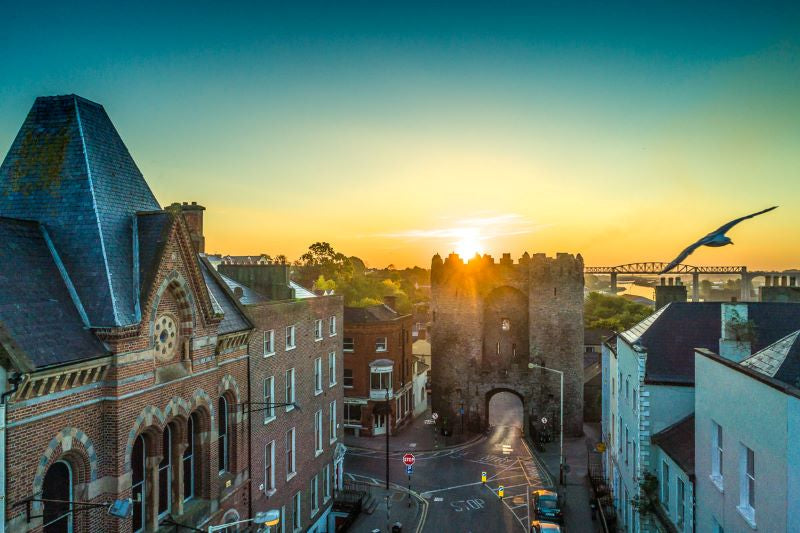
St. Laurence's Gate, which led to the Friary of St Laurence, is widely regarded as one of the finest of its kind in Europe. It consists of two lofty circular towers, connected together by a wall, in which there is an archway. Visitors can appreciate the spectacular dimensions of the mediaeval walls south of the gate at Featherbed Lane. The gates and walls not only protected the town but also controlled access to the markets; traders had to pass through the gates and pay taxes on their produce.
Twice the walls and gates of Drogheda held strong against invasion, firstly when Edward Bruce (brother of Robert Bruce I of Scotland) attacked the town in 1317 and again in 1642 when Sir Phelim O'Neill attempted to take Drogheda from its English garrison.
In 1649, Oliver Cromwell breached the walls and sacked the town, massacring 2,000 Royalist sympathisers and deporting captives as slaves to Barbados. In 1690 Drogheda surrendered to King William after he defeated his father-in-law James II at the nearby Battle of the Boyne.
King John’s Castle
King John's Castle is located on the southern shores of Carlingford Lough.
The original castle consisted of an enclosed courtyard with two rectangular towers at the entrance and two-storey buildings within. The eastern half of the castle was added in 1261 ad and included a number of rooms and probably a great hall. There were a number of alterations made to the castle over the centuries.

Carlingford Castle appears to have remained in English hands during the post-mediaeval period. Hugh O'Neill, Earl of Tyrone, tried to take the castle in a surprise attack in 1596. The castle changed hands several times over the following centuries and was fired upon by retreating Jacobite forces in 1689. It also functioned as a hospital during the period leading up to the Battle of the Boyne.